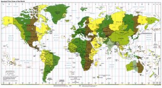
Looking at a world time-zone map (click on the small image to view an enlarged image), I'm struck by the oddity of certain artifacts. For practical reasons, people don't want time zone changes right in the middle of major geographic entities (a city, say - or even a smallish state), and as a result, some zones are distended several hours from the time they'd be basing their time solely on solar noon. One of the more striking examples is Alaska (unfortunately split in half on this map), which from east to west would span four time zones, but is almost entirely in a zone one hour later than U.S. Pacific time. This already places the bulk of the state an hour earlier than its geographic location would suggest...but a further absurdity arises when a handful of the westernmost Aleutian Islands is in the next westerly time zone - even though its location is about three hours west of the central meridian for 9 hours after GMT, and in fact would cross the International Date Line if not for a convenient bend. Is there that much going on out there that two hours' difference would cause such havoc?

On the other hand, some locations seem almost absurdly punctilious in attempting to match local time to solar time, with their time being half an hour different from the adjacent time zone (India, Newfoundland) and - in the case of the tiny Chatham Islands off New Zealand, forty-five minutes different. Wouldn't it be easier just to be fifteen minutes late?
Anyway, here's a Cold War artifact on certain implications of this subject:
Negativland "Time Zones"


3 comments:
Straight lines in the time meridians on land are the exception, rather than the rule. They pretty much only occur in places where few people live (north central Canada, the Australian outback) or where they are following a political boundary that just happens to be in a straight North-South line already (the western United States). So the habit is already established to bend them to suit the populace. After that it is just a question of degrees.
A bigger absurdity is "Daylight Saving(s [sic]) Time". And then beyond that still, is noodling with it in an attempt to produce mythical energy savings. Being the suspicious type, I'm pretty sure it was actually lobbyists for the candy industry that got beginning/end days moved. They'll be making more money when kids go out at the same (clock) time as usual on Halloween, but still stay out until dark. Most of the past attempts bombed when enough people noticed the chocolate fingerprints on them.
I like the Halloween Conspiracy Theory. It just so happens that the Chatham Islands has the planet's largest nougat mines. And while it's true that straight lines are the exception, what's amusing to me is how far some things are bent out of alignment, not the mere fact that they are. (Dammit, now you're making me hungry.)
If I'm remembering correctly, the barbecue industry was one of the ones that lobbied to move the start of Daylight Savings time from the end of April to the beginning of April in 1986.
Post a Comment